
Vaizdas:Languages of CE Europe-3.PNG
Šios peržiūros dydis: 524 × 599 taškų. Kitos 3 rezoliucijos: 210 × 240 taškų | 419 × 480 taškų | 951 × 1 088 taškų.
Pradinė rinkmena (951 × 1 088 taškų, rinkmenos dydis: 769 KiB, MIME tipas: image/png)
Aprašymas
| Aprašymas |
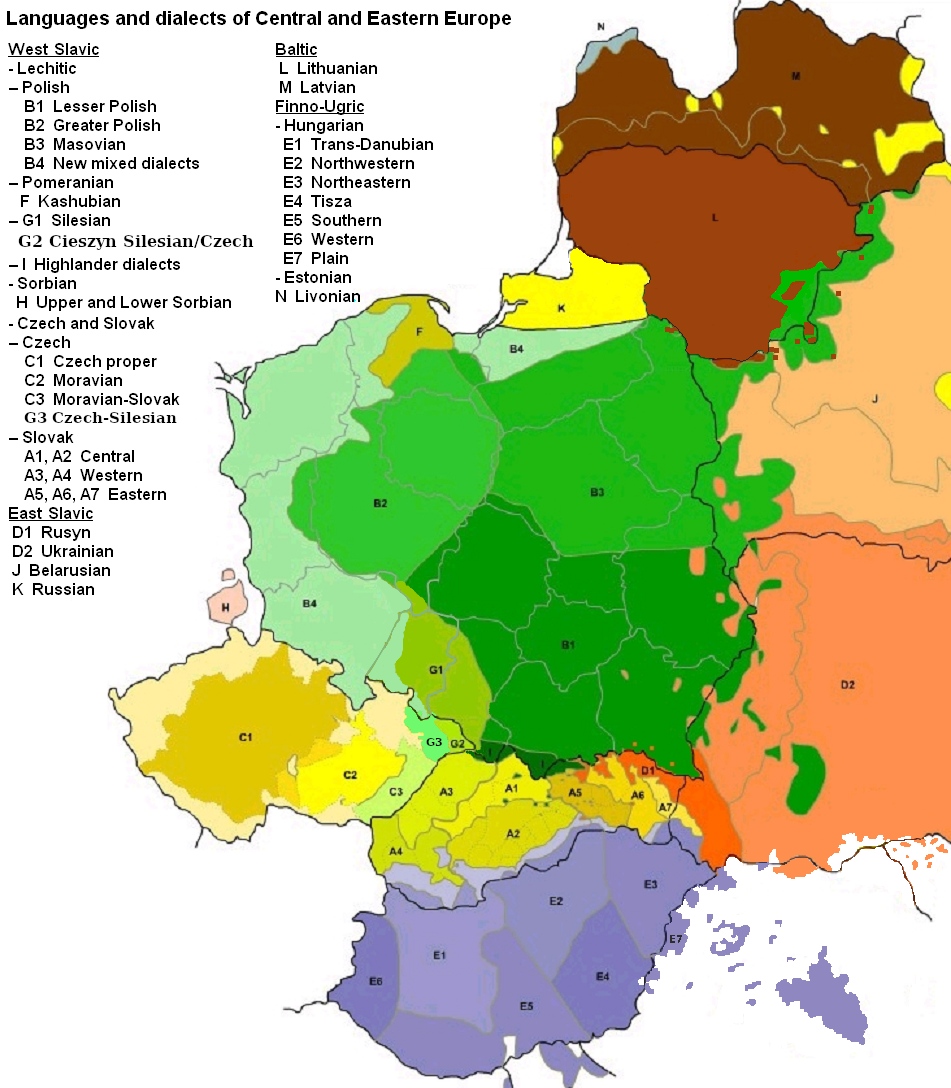
English: Map of languages and dialects of Central and Eastern Europe
Polski: Języki i dialekty Europy Srodkowo-Wschodniej
Deutsch: Legende:
|
||
| Data | |||
| Šaltinis |
Mano darbas |
||
| Autorius | |||
| Kitos versijos |
|

|
Šis paveikslėlis linguistic map (arba visos šio straipsnio iliustracijos) turėtų būti iš naujo sukurtas naudojant vektorinę grafiką, kaip, pavyzdžiui, SVG failas. To privalumus ir daugiau informacijos rasite straipsnyje Commons:Media for cleanup. Jei šio failo SVG versija jau sukurta, prašome ją įkelti. Po įkėlimo šios iliustracijos puslapyje pakeiskite šį šabloną į {{vector version available|naujas paveikslėlio pavadinimas.svg}}.
|
Licencija

|
Suteikiamas leidimas kopijuoti, platinti ir/ar redaguoti šį dokumentą pagal GNU Free Documentation licencijos versijos 1.2 ar bet kurios vėlesnės versijos sąlygas, publikuotas Free Software Foundation; be nekintamų dalių, be priekinių ir galinių tekstinių žymų viršeliuose. Šios licencijos kopija įtraukta dalyje, pavadintoje GNU Free Documentation License. |
| Šiam failui taikoma Creative Commons Attribution-Share Alike 3.0 Unported licencija. | ||
| Autoriaus nurodymas: Zaragoza, Kpalion, Dellijks | ||
| ||
| Licencijos šablonas buvo priskirtas šiam failui kaip GFDL licencijos atnaujinimo dalis. |
Originalus įkėlimo įrašas
This image is a derivative work of the following images:
- File:Languages_of_CE_Europe.PNG licensed with GFDL
- 2008-08-25T20:42:18Z Kpalion 951x1088 (1053557 Bytes) {{Information |Description={{en|Map of languages and dialects of Central and Eastern Europe}} |Source=*[[:Image:Jezyki_i_dialekty_Europa_Srodkowo_Wsch..jpg|]] |Date=2008-08-25 20:40 (UTC) |Author=*derivative work: ~~~ *[[:Ima
Rinkmenos istorija
Paspauskite ant datos/laiko, kad pamatytumėte rinkmeną tokią, kokia ji buvo tuo metu.
| Data/Laikas | Miniatiūra | Matmenys | Naudotojas | Paaiškinimas | |
|---|---|---|---|---|---|
| dabartinis | 06:47, 17 rugpjūčio 2019 | | 951 × 1 088 (769 KiB) | D T G | G1 - changed western border (compare my other map: File:Gwary śląskie wg Zaręby.png - sources there); G2 - changed name and classification (this was part of the Polish Cieszyn Silesian, after 1920 evolving towards Czech, but it was absurd that it would be classified as Czech when to South-West was just G1, not differentiated from G1 in Poland! I repeat it was absurd!, therefore I created G3, see below); G3 - created Czech-Silesian also know as Lach dialects, up to 1980s regarded by some... |
| 07:42, 17 rugpjūčio 2015 |  | 951 × 1 088 (928 KiB) | Winnetou14 | Reverted to version as of 19:28, 13 September 2009 | |
| 23:11, 11 lapkričio 2009 |  | 951 × 1 088 (697 KiB) | Alex Tora | {{Information |Description= |Source={{own}} |Date= |Author=Alex Tora |Permission= |other_versions= }} | |
| 19:28, 13 rugsėjo 2009 |  | 951 × 1 088 (928 KiB) | Scooter20 | Fixed Hungarian & Ukrainian in Romania, Ukrainian in Moldova and Romanian in Hungary and Ukraine | |
| 22:16, 19 liepos 2009 |  | 951 × 1 088 (982 KiB) | Dellijks | {{Information |Description={{en|Map of languages and dialects of Central and Eastern Europe}}{{pl|Języki i dialekty Europy Srodkowo-Wschodniej}} {{de|-> * B1 - Kleinpolnisch * B2 - Großpolnisch * B3 - Masowisch * B4 - Hochpolnisch * F - Kaschubisch * G1 |
Rinkmenos naudojimas
Rinkmena nėra naudojama jokiame puslapyje.
Visuotinis rinkmenos naudojimas
Ši rinkmena naudojama šiose viki svetainėse:
- Naudojama af.wikipedia.org
- Naudojama als.wikipedia.org
- Naudojama am.wikipedia.org
- Naudojama ang.wikipedia.org
- Naudojama an.wikipedia.org
- Naudojama arz.wikipedia.org
- Naudojama ast.wikipedia.org
- Naudojama bo.wikipedia.org
- Naudojama br.wikipedia.org
- Naudojama csb.wikipedia.org
- Naudojama cs.wikipedia.org
- Naudojama cv.wikipedia.org
- Naudojama da.wikipedia.org
- Naudojama de.wikipedia.org
- Naudojama diq.wikipedia.org
- Naudojama el.wikipedia.org
- Naudojama en.wikipedia.org
- Naudojama en.wiktionary.org
- Naudojama eo.wikipedia.org
- Naudojama eu.wikipedia.org
- Naudojama frr.wikipedia.org
- Naudojama fr.wikipedia.org
- Naudojama fur.wikipedia.org
- Naudojama fy.wikipedia.org
- Naudojama gd.wikipedia.org
- Naudojama he.wikipedia.org
- Naudojama hr.wikipedia.org
- Naudojama hsb.wikipedia.org
- Naudojama hy.wikipedia.org
- Naudojama incubator.wikimedia.org
- Naudojama ka.wikipedia.org
- Naudojama ko.wikipedia.org
- Naudojama la.wikipedia.org
- Naudojama mg.wikipedia.org
- Naudojama ms.wikipedia.org
- Naudojama nl.wikipedia.org
Žiūrėti visuotinį šios rinkmenos naudojimą.